Protect Stafford, GUEST POST
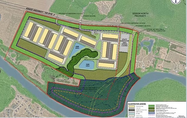
On Wednesday, November 18, the Stafford County Planning Commission will hold a public hearing on four proposed hyperscale data center projects along the Rt 3 corridor in Southeastern Stafford: Forest Lane, Simms Farm, Sisson North, and Sisson South.
The Kings Corridor project, as it is referred to by the developer, Peterson Companies, consists of over 1,400 acres of rural land, covering 9 million square feet of data center space across 37 total buildings. Based on size, the total project is one of the largest data center projects in Central and Northern Virginia and likely the largest rezoning initiative considered by Stafford.
The Wednesdayh hearing will take place at 6 pm at the Stafford Government Center. Due to significant public interest, the hearing is expected to last past midnight.
In addition to the extraordinary scale, these sites are located along the banks of the Rappahannock River and astride a large old growth forest reported to be present at the first colonization of Virginia approximately 400 years ago.
“Beyond the sheer acreage involved, the four projects propose 14 electrical substations occupying 115 acres, with a combined power demand of approximately 2.75 gigawatts. These figures are so far outside ordinary experience that it is nearly impossible for people to comprehend what development on this scale would actually mean for a community,” said Erin Sanzero, President of the local data center education and policy advocacy group, Protect Stafford.
An independent sound study commissioned by Protect Stafford found that sound levels in some areas will be allowed to increase by as much as 30 decibels. “To make matters worse, the county’s noise standards never apply to substations nor when emergency backup power generators run. They also do not apply to the 8-plus year construction period,” said Kevin French, Vice President of Protect Stafford.
Finally, these projects will require an extensive network of new power lines and water and sewer connections extending well beyond the development sites themselves. The plans do not yet identify the full routes of this infrastructure, leaving unanswered questions about whose property it may cross and what forests, wetlands, streams, and other sensitive areas could be affected. The applicant’s proposals ask Stafford County to use condemnation (eminent domain) to obtain necessary utility easements if agreements with landowners cannot be reached.
On October 20, the Board of Supervisors authorized condemnation of easements on nine parcels for a reclaimed water pipeline serving data centers in northern Stafford, including Amazon’s Potomac Church project. Litigation challenging the county’s use of eminent domain for data center infrastructure is pending.
The project’s enormity is reflected in the sheer volume of material required to evaluate it. With over 5,000 pages of application materials and staff reports, meaningful review is a formidable undertaking for residents, organizations like Protect Stafford, County staff, and Planning Commissioners alike. Nevertheless, 11 separate matters are to be presented, discussed, and voted on in a single evening. This raises serious questions as to whether the process allows for adequate consideration of each application, much less the cumulative consequences of all four projects.
“There does not seem to be a comprehensive method for evaluating what these projects would do to the corridor as a whole. Given the combined changes to land use, noise, the sprawling electrical network, forest continuity, and sensitive waterways, this strains the ability of the public, staff and appointed officials to deal with the complex and compounding issues of ruling on 4 separate projects that are essentially a single intertwined complex of inter-dependent projects,” commented Sanzero.
French added, “At this scale, the question is not simply whether each individual project can meet certain requirements. It is whether the combined development fundamentally changes the character and pattern of land use in this part of Stafford County, and how the County is able to assess and account for that change.”